MAPP (Maritime Autonomous PNT Prototype)
MAPP
(Maritime Autonomous PNT Prototype)
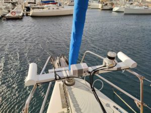
The world economic trade has continuously increased over the past decades. For the maritime business, this had led to larger and larger ships and denser traffic. Examples of famous waterways are the Suez Channel, the Kiel Channel, and the Malakka Strait near Singapore. The latter one is passed by 200 to 250 container ships daily that transport 25 % of the global maritime transportation freight. Obviously, this huge amount of shipping through narrow waterways makes the maritime transport very susceptible to accidents. Harbours and water gates are even more frequently used and are particularly challenging for navigation. This shows the strong need for assisted as well as autonomous navigation. In both cases, there is a strong need for a precise and reliable positioning and attitude determination. MAPP aims to develop a precise predictor which will be beneficial for large ships due to their high inertia and, thereby, slow reaction times. This predictor will be based on GNSS and INS systems complemented by a wide array of complementary heterogeneous sensors including odometer, visual cameras, ranging sensors (LiDAR, Radar, etc.), IMUs, multi-GNSS antennas. The emphasis is on combining all this sensor data to determine a precise vessel’s attitude in challenging scenarios – port approach, port navigation and docking – by applying sensor fusion, filtering and data analysis by developing AI/ML techniques along some of the processes.
At ANavS, we are responsible for both hardware and software advancements within the project:
- Hardware Platform set-up including GNSS, IMU, LiDAR, and camera sensors.
- Software Modules:
- GNSS-PPP and IMU tightly coupled filter
- LiDAR SLAM algorithm
- Multi-sensor fusion of localization algorithms
- Definition & implementation of a multi-sensor integrity concept for precise position and attitude
Sie sehen gerade einen Platzhalterinhalt von YouTube. Um auf den eigentlichen Inhalt zuzugreifen, klicken Sie auf die Schaltfläche unten. Bitte beachten Sie, dass dabei Daten an Drittanbieter weitergegeben werden.
Mehr Informationen- 01/2023 – 07/2025
- Jorge Moran Garcia
Quick overview
Products
Equipped for every situation with the need of high-precise positioning & navigation:V-ROX, A-ROX, G-ROX, MSRTK, Snow Monitoring and M.2 SMART Card.
R&D Projects
Our R&D team is constantly working on researching, developing and implementing new technologies to master the challenges of tomorrow.
Publications
Our publications are varied, provide well-founded findings and present innovative solutions: Journal and Conference papers, Patents and Theses