Snow Monitoring

Snow Monitoring Station
Meteorological information systems
Accurate determination of SWE, snow height and LWC based on differential GNSS measurements
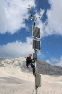
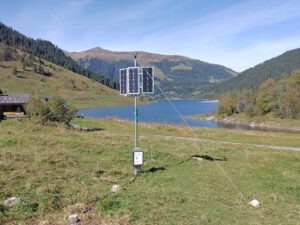
The ANavS® snow monitoring stations provide accurate snow pack information based on Global Navigation Satellite System (GNSS) signals. The Snow Water Equivalent (SWE), snow height and Liquid Water Content (LWC) are determined with innovative algorithms within the stations.
The snow pack properties are transferred via satellite communications or cellular networks. Access to the snow information is provided via email or web service. The stations operate autonomously with an integrated solar-power supply and wireless communication, and can be set up permanently or temporarily. To get centimeter accuracy for your application, you need correction data from a static base station (RTCM Station). ANavS® provides RTCM Stations with additional benefits for your positioning solution.


Applications
- Meteorological information systems
- Optimized operation of hydro-power plants enabled by accurate run-off prediction
- Monitoring of roof load caused by snow
- Scientific research on snow pack modeling and avalanches
Key Features
- Accurate determination of SWE, snow height and LWC based on differential GNSS measurements
- Cost-efficient monitoring instead of time-consuming manual measurements
- Weather-independent operations by no use of optical sensors/ lasers
- Outperformance of snow scales as GNSS measurements are independent of bridging effects
- Solar power supply for remote installations
- Efficient power management with extremely low power sleep mode and configurable schedule
- Iridium or cellular wireless communication for remote installations
- Access to GNSS raw measurements
- Processing of GNSS raw measurements within snow monitoring station
- Remote re-calibration of station via satellite communication (Iridium)
Quick overview
Products
Equipped for every situation with the need of high-precise positioning & navigation:V-ROX, A-ROX, G-ROX, MSRTK, Snow Monitoring and M.2 SMART Card.
R&D Projects
Our R&D team is constantly working on researching, developing and implementing new technologies to master the challenges of tomorrow.
Publications
Our publications are varied, provide well-founded findings and present innovative solutions: Journal and Conference papers, Patents and Theses