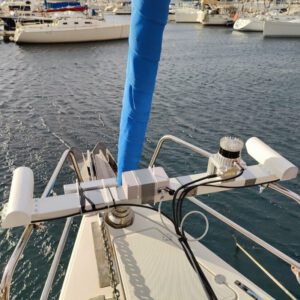
ANavS, in partnership with Space Applications Services NV/SA, recently conducted a data campaign aboard a sailboat as part of the ESA MAPP project. MAPP (Maritime Autonomous PNT Prototype) is a groundbreaking initiative aimed at developing an advanced system for precise position and attitude determination using GNSS receivers, cameras, Lidar, and other sensors. By integrating Artificial Intelligence (AI) techniques, MAPP seeks to enhance the performance and resilience of maritime PNT solutions, offering highly accurate navigation data crucial for improving vessel automation and supporting operations during docking and port navigation phases.
Our mission? To assess the accuracy and robustness of our system in real-world maritime scenarios. Equipped with a diverse range of sensors – three GNSS antennas, three IMUs, two Lidars, and three cameras – we set out to meticulously capture, analyze, and interpret data.
All further information on the project can be found here.