🚢 We are proud to announce the successful completion of the MAPP project, carried out in partnership with European Space Agency – ESA and our consortium partners Space Applications Services NV/SA.
👉 MAPP focused on developing and demonstrating alternative PNT (Positioning, Navigation, and Timing) concepts to enhance ship operations in ports.
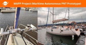
👉 At ANavS, we were responsible for both hardware and software advancements within the project:
➡️ Hardware Platform set-up including GNSS, IMU, LiDAR, and camera sensors.
➡️ Software Modules:
✅ GNSS-PPP and IMU tightly coupled filter
✅ LiDAR SLAM algorithm
✅ Multi-sensor fusion of localization algorithms
✅ Definition & implementation of a multi-sensor integrity concept for precise position and attitude
Two extensive campaigns were conducted in different ports and on different vessels (see video attached). The results confirmed that the developed system not only delivers high accuracy, but also ensures resilience to GNSS outages and robustness against potential sensor faults – thanks to our multi-sensor fusion approach.
🔷 The project was successfully finalized in July 2025, with the Final Review held at ESA ESTEC.
🔜 Stay tuned – the Final Presentation will soon be made publicly available.