A-ROX
High-Precision GNSS-INS Sensor Fusion for Autonomous and Mobile Systems
A-ROX
GNSS-INS tightly coupled positioning system
Ground truth measurement equipment providing resilient positioning and motion data for autonomous driving, ADAS testing, railway, maritime, mobile mapping and unmanned applications.
0.01m
Position accuracy
0.01 km/h
Velocity accuracy
0.05°
Heading accuracy
0.02°
Roll/Pitch accuracy
A-ROX by ANavS is a high-performance GNSS-INS sensor fusion platform providing centimetre-level positioning, orientation and vehicle dynamics data for autonomous vehicles, ADAS test systems and other safety-critical mobile applications.
It enables reliable localisation in urban environments, tunnels, rail corridors and GNSS-challenged areas, supporting both real-time navigation and ground-truth reference data.
Technical Overview
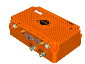
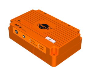
The ANavS® A-ROX module provides precise position, velocity and attitude information, by tightly coupling GNSS, IMU and odometer data, and applying PPP or RTK corrections to the GNSS code and phase measurements.
The A-ROX version supports Galileo High Accuracy Service (HAS) service (both via SIS and IDD) and OSNMA for navigation data accuracy. The A-ROX system comes with a ROS2 software architecture, which leads to access to all sensor raw data and solution outputs with ROS2 topics. This software architecture makes it very powerful for an easy integration in other toolchains and subsystems.
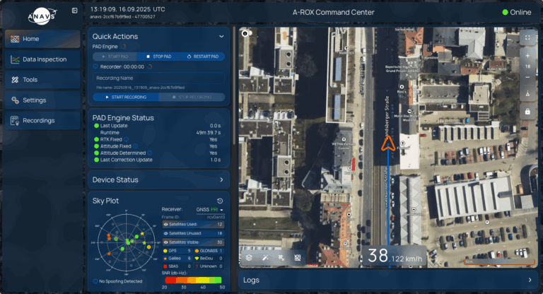
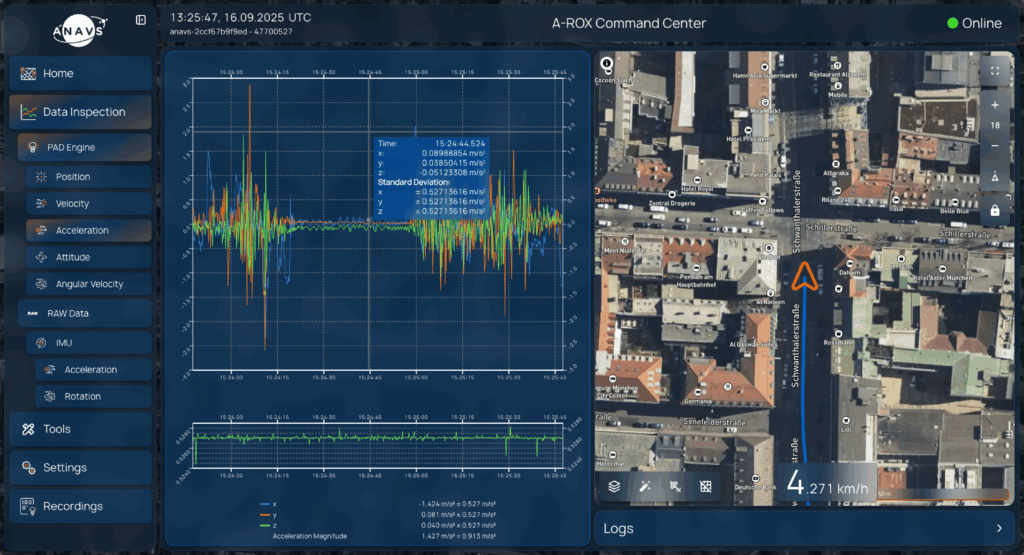
A powerful Web-App completes the ecosystem of A-ROX. The new interface will make the system more accessible and user friendly. It will also open the door for its integration in fleet management systems, with the option to control all the devices in a centralised manner. A powerful postprocessing tool is hosted in the web-app.
ANavS Hub Software Suite
Cloud-based User-Interface with Postprocessor and Fleet management system
Precision,Efficiency and Control in One Platform
Our Fleet Management & Post-Processing System is a powerful backend platform that enables seamless monitoring, data analysis, and optimization of vehicle operations across various industries.
Key Features & Benefits
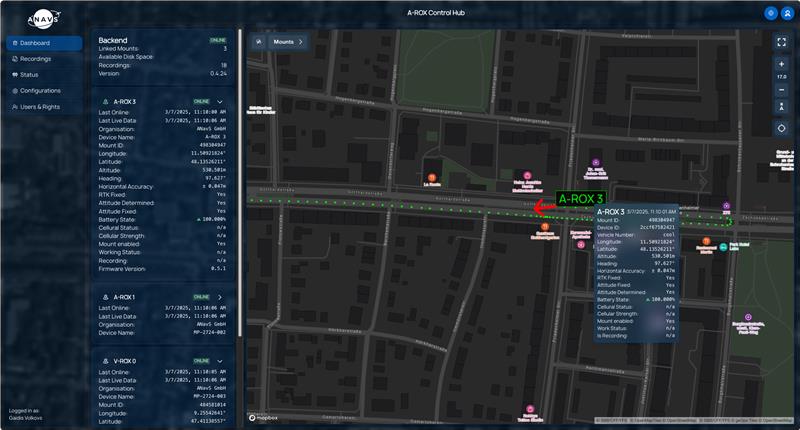
- Real-Time Fleet Monitoring:Track the precise position, velocity, and attitude of every vehicle in your fleet.
- Cloud-Hosted Web Application: No installation required – access fleet data securely from any device.
- Automated Post-Processing: Utilize advanced forward-backward processing to enhance positioning accuracy.
- RTK & PPP Correction Management: Seamlessly switch between RTK and PPP modes based on correction data availability.
- Comprehensive Sensor Fusion: Incorporates GNSS, IMU and odometry data for high-precision localization.
- Secure Data Logging & Analysis: Store and evaluate historical data to improve fleet performance.
ANavS Fleet
Application Areas
- Autonomous Vehicle Testing: Ensure accurate ground-truth reference data for ADAS validation, measuring dynamics and brake distances
- Rail & Maritime Operations: High-precision tracking for safe and efficient transportation and for maintenance work.
- Surveying & Mapping: Improve georeferencing accuracy with our post-processing engine.
- Logistics & Industrial Fleets: Optimize routes and resource utilization.
A-Hub Data Plans
Free
Manage all your devices in one place
Dashboard with live view
Remote access to A-ROX devices including device configuration
Users & Rights
Deployment and Updates for your fleet of A-ROX devices
Cloud storage
50 GByte per device
Basic
Manage all your data campaign recordings for your fleet
+ all functions from Free
Automatic recording synchronization
Forward reprocessing of datasets with latest sensor fusion engine
Configuration changeable for Postprocessing (e.g. antenna distances, lever arms, etc.)
Access to API for automation
Access to Converter Tools (e.g. mcap to raw binary, mcap to Rinex, etc.)
Sensor fusion engine version selectable
Cloud storage
50 GByte per device
Premium
Take full advantage of the post-processing for best data
+ all functions from Basic
Powerful Forward/ Backward Postprocessing
Missing RTK or PPP solution can be processed additionally.
- RTK: RTCM data (as RINEX-file) can be added in case they were not recorded in real time.
PPP: Automatically added correction data afterwards (Rapid, Final, etc.)
Cloud storage
1 TByte per device
Enterprise
Please contact us for customized solutions
Our features - Your advantage
Shaping the future of positioning – with customized solutions for every application.
Product Overview
Centimetre-accurate positioning thanks to RTK and PPP (incl. Galileo HAS)
Seamless transition between RTK and PPP corrections
FOG-grade MEMS IMU for precise position information in the event of GNSS failure
Tightly Coupled Sensor Fusion with odometry, GNSS and IMU
Robust, compact IP65 housing – 174 × 123 × 60 mm
Live data access via 5G, Wi-Fi and Ethernet
Supports ROS2, CAN-FD, NMEA, FAST-API and ACOM
Cloud-based control hub for remote configuration and data analysis
Made in Germany – quality, reliability, durability
Application Overview
Automotive & Autonomous driving
Railway & Rail network
Surveying & Mapping
Maritime & UAV
- Ground truth for ADAS test systems
- Localisation for autonomous vehicles
- SLAM support in tunnels or cities
- Vehicle dynamics tests (pitch, yaw, roll)
- Track surveying & maintenance monitoring
- Position data for autonomous maintenance vehicles
- Fleet management & precise odometry integration
- Georeferencing of LiDAR, camera and radar
- Trajectories with centimetre accuracy for mobile mapping
- Navigation in urban canyons & underground facilities
- Offshore navigation & dynamic positioning
- Navigation for unmanned aerial vehicles
- Stability data for autonomous systems
Our product promise
Best possible positioning accuracy thanks to advanced GNSS sensors and integrated correction data service
Up to 3 GNSS receivers suitable for surveying – for precise positioning – are available. The raw data from all receivers is available (at up to 100 Hz), as is a PPS signal. Compliance with specifications proven in practice. An integrated modem enables the use of all correction data services available worldwide, such as RTK (RTCM3, OSR) or PPP correction data (RTCM3, SSR), without additional hardware. The corresponding services can be booked with DTC.
Intuitive and simple handling
Modern web-based user interface with remote access, app, simple configuration, automated version management.
Can be used worldwide without special export restrictions
Duty-free import, no dual-use and export restrictions (ITAR-free).
Reliable measurement accuracy due to initial DAkkS calibration
Initial delivery includes DAkkS calibration (SPEKTRA), calibration in Germany minimises downtime.
No cable chaos
Internal WLAN and LTE modem, so fewer cables and devices are required in the test vehicle, fewer sources of error, i.e. one system – all functions.
Expertise advantage through R&D projects
Thanks to intensive research and development (R&D) projects, we have a knowledge and innovation advantage in order to develop advanced solutions and technologies faster and more effectively that have not yet been implemented in comparable systems (e.g. HAS, PPP, OSNMA).
Overview A-ROX
The A-ROX GNSS-INS tightly coupled positioning is the real-time ground truth measurement equipment for dynamic automotive, railway and maritime applications. It is used for ADAS and autonomous vehicle testing, endurance tests, fleet tests, survey and mapping from land, water and air, georeferencing of cameras, lidars and radar sensors, logging of parameters during vehicle tests and machine automation.
Three different versions of A-ROX are available:
- A-ROX-PRO
- A-ROX-RTK
- A-ROX-PPP
- ADAS
- Autonomous vehicle testing
- Endurance tests
- Fleet tests
- Survey & mapping from land, water and air
- Georeferencing of cameras, lidars and radar
sensors - Logging of parameters during vehicle
tests (CAN) - Machine automation
The patented tightly coupled sensor fusion algorithms integrate survey-grade GNSS raw measurement data (multi-constellation, multi-frequency), RTK and PPP (HAS and terrestrial) correction data, inertial sensor data (FOG-grade MEMS IMU) and odometry data for a highly accurate position, velocity and attitude solution, even in challenging GNSS environments. A smart handover from RTK to PPP technology, based on the reception of correction data, provides a unique positioning performance. A powerful forward-backward post-processing engine is available to further enhance the accuracy of the position, velocity and attitude solution with all recorded sensor raw data.
The A-ROX system is built on a new modular hardware platform, delivering improved processing capabilities and upgraded interfaces. The system can be configured with single, dual or triple GNSS antenna (s). The processing unit is part of the A-ROX system. A powerful configuration and visualization software is implemented as a web app, easily accessible from different kinds of devices, including laptops and tablets. It is directly hosted on the system with no need for installation of software on your device. On top of the local app, a cloud-based fleet management feature is available for controlling all you’re aROX devices and accessing all sensor data from anywhere.
The A-ROX system comes with integrated 5G module, providing access to RTK and PPP correction data and enabling remote view and system configuration very user-friendly.
Further interfaces are:
- Wi-Fi
- Gigabit Ethernet
- USB-C
- up to 4 CAN-FD channels
Trigger events, like wheel ticks, can be fed through the GPIOs into the sensor fusion framework.
There are several output formats available with a maximum rate of 200 Hz (1000 Hz optional):
- ROS 2
- NMEA
- ACOM
- CAN
| GNSS Constallations | Galileo, GPS, Glonass, Beidou, SBAS (EGNOS, WAAS, GAGAN) |
Positioning accuracy | 0.006 m RTK; 0.2 m PPP |
Roll/Pitch | 0.01° |
Velocity accuracy | 0.03m/s RMS |
Heading | 0.05° |
Slip angle accuracy | 0.15° |
Data output rate | Maximum rate of 200 Hz available: ROS2, NMEA, ACOM |
Operating temperatue | -20°………..65° |
IP Rating | IP65 |
Power consumption | Average 15W |
Dimensions | 140 x 200 x 60 mm |
Weight | 1,7 kg |
Storage | 16 GB internal, upgradable with NVME SSD up to 2 TB |
Interfaces | Gigabit Ethernet, Wi-Fi, 5G 2×2 MIMO cellular network, up to 4x CAN-FD channels, USB 3.1, 4 GPIO, PPS and sync in |
Dual Antenna / Triple Antenna | Yes / Yes |
Tightly Coupled Sensor Fusion Performance
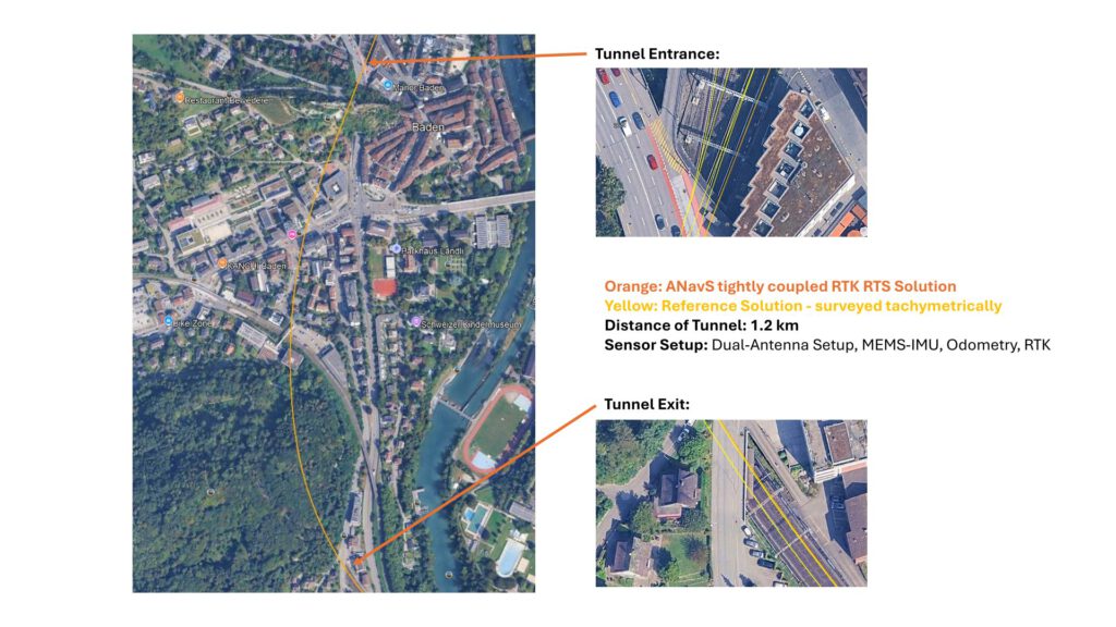
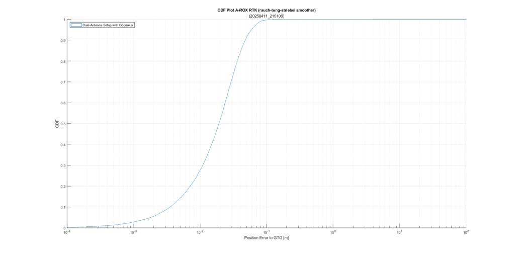
Our GNSS/INS/Odometry tightly coupled positioning and attitude engine demonstrates outstanding accuracy and robustness – even in challenging environments such as tunnel passages.
The left image illustrates the trajectory through a 1.2 km long tunnel (location: Baden, Switzerland):
Orange: ANavS® tightly coupled RTK-RTS (rauch-tung-striebel smoother) solution
Yellow: Reference trajectory, surveyed tachymetrically –
By combining dual-antenna GNSS, MEMS-IMU, odometry, and RTK correction data, the ANavS® solution remains stable even without GNSS visibility and delivers a trajectory that closely follows the highly precise reference line.
The right diagram shows the position error statistics (CDF). The results confirm that our tightly coupled fusion ensures very high accuracy ground truth and maintains solution integrity even during temporary GNSS outages.
With this technology, ANavS® provides reliable navigation for applications where continuity, precision, and robustness are critical – from autonomous driving to marine operations and demanding infrastructure projects.
A-ROX PRO
AX-PRO
A-ROX PRO navigation system with GNSS(RTK/PPP)+ INS + Odometry sensor fusion engine. Includes the latest Galileo HAS (High-Accuracy-Service) technology. The perfect solution where RTK correction data failures (no internet connection) cannot be tolerated and must be bridged by satellite-based correction data like Galileo HAS correction data.
- Single antenna
- Dual antenna
- Triple antenna
A-ROX RTK
AX-RTK
A-ROX RTK navigation system with GNSS(RTK) + INS + Odometry sensor fusion engine. The perfect solution for highly reliable and accurate position, orientation and dynamics data in all environments.
- Single antenna
- Dual antenna
- Triple antenna
A-ROX PPP
AX-PPP
A-ROX navigation system with GNSS(PPP) + INS + Odometry sensor fusion engine. Includes the latest Galileo HAS (High-Accuracy-Service) technology. The perfect solution for accurate position, orientation and dynamics data in all environments, without the need of additional infrastructure getting RTK correction data.
- Single antenna
- Dual antenna
- Triple antenna
Quick overview
Products
Equipped for every situation with the need of high-precise positioning & navigation: AI-ROX, A-ROX, G-ROX, MSRTK, Snow Monitoring and M.2 SMART Card.
R&D Projects
Our R&D team is constantly working on researching, developing and implementing new technologies to master the challenges of tomorrow.
Publications
Our publications are varied, provide well-founded findings and present innovative solutions: Journal and Conference papers, Patents and Theses
